- আমাদের সম্পর্কে
-
আমাদের সেবা
প্রশিক্ষণ ও পরামর্শ
পরিদর্শন
-
অন্যান্য কার্যালয়
বিভাগীয়/উপজেলা কার্যালয়
মন্ত্রণালয়/বিভাগ/অধিদপ্তর
- ই-সেবা
- গ্যালারি
-
যোগাযোগ
অফিস যোগাযোগ
যোগাযোগ ম্যাপ
- আমাদের সম্পর্কে
-
আমাদের সেবা
প্রশিক্ষণ ও পরামর্শ
পরিদর্শন
-
অন্যান্য কার্যালয়
বিভাগীয়/উপজেলা কার্যালয়
মন্ত্রণালয়/বিভাগ/অধিদপ্তর
- ই-সেবা
- গ্যালারি
-
যোগাযোগ
অফিস যোগাযোগ
যোগাযোগ ম্যাপ
The District Family Planning office of Cox’s Bazar is under the Ministry of Health and Family Welfare and Medical Education and Family Welfare Division has been playing a key role in conducting maternal, child, reproductive health care, family planning activities in Bangladesh, which has a small size, limited resources, a large population. The District Family Planning Office is located in the Swapnil Bhavan on the south side of the main road near Kalur Dokan in the heart of Cox's Bazar city. The office successfully manages various government programs in Cox's Bazar district through Maternal and Child Welfare Center, Upazila Family Planning Office, Union Health and Family Welfare Center, Community Clinic and Satellite Clinic, Family Planning, Maternal, Child Health, Reproductive Health, Adolescent Services. Ongoing. Illiteracy, superstition, orthodoxy, conservatism are the main obstacles in the way of dynamism in the activities here. It lacks adequate manpower and infrastructural facilities. Nevertheless, due to the dedicated work and dedication of all the employees, significant progress has been made in the departmental activities in recent years. The Family Planning Department gratefully expects the continued support and cooperation of the people of the district, public representatives, social and religious leaders, all government and non-government organizations, development partners, the media for the successful implementation of their program.
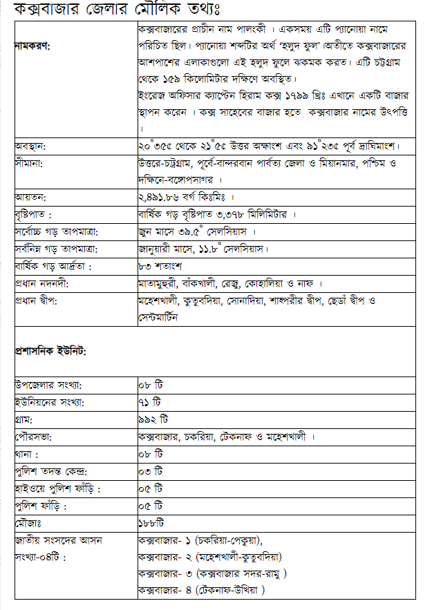
Basic Information of Cox’s Bazar District:
|
Naming |
The Ancient name of Cox’s Bazar was "Palongkee. Once Cox's Bazar is also known by the name Panowa. Panowa means"yellow flower. In the past, the surrounding areas of Cox's Bazar were flaming these yellow flowers. It is located 159 kilometers south of Chattagram. English officer Captain Hiram Cox established a market here in 1799 AD. Cox's Bazar originates from the Bazar of Cox saheb. |
|
Location |
Cox’s Bazar located in between 20°43' and 21°56' north latitudes and in between 91°50' and 92°23' east longitudes. |
|
boundary |
|
|
Area |
2491.86 Sq. km |
|
Rainfall |
Annual average rainfall is 3,378 maximum |
|
Maximum average temperature in |
In June, 39.50 Celsius |
|
Minimum average temperature in |
In January, 11.80 Celsius |
|
Annual average humidity |
83 Percent |
|
Main river |
Matamuhuri, Bakkhali, Reza, Kohelia, and Naf |
|
Main island |
Moheshkhali, Kutubdia, Sonadia, Shahpari Island, Chera, and St. Martin Island |
Administrative Unit:
|
Number of Upazila: |
08 |
|
Number of Union: |
71 |
|
Village: |
992 |
|
Municipality: |
Cox's Bazar, Chakaria, Teknaf, and Moheshkhali |
|
Police Station: |
08 |
|
Police Investigation Centre: |
03 |
|
Highway Police Outpost: |
05 |


পরিকল্পনা ও বাস্তবায়নে: মন্ত্রিপরিষদ বিভাগ, এটুআই, বিসিসি, ডিওআইসিটি ও বেসিস
কারিগরি সহায়তায়:
![]()
সফটওয়্যার তৈরি:
